
Maine Cabin Guidebook
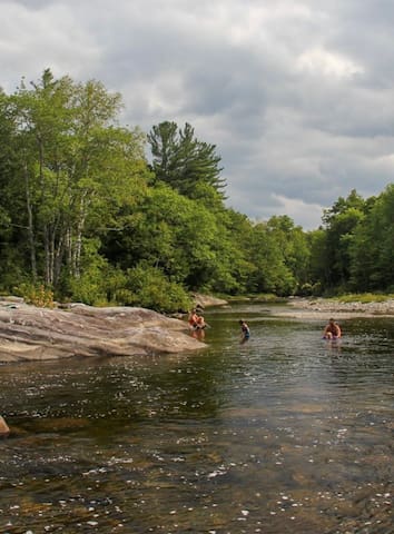
Swimming Hole
Wire Bridge, New Portland, Maine
The Wire Suspension Bridge spanning the Carrabassett River in New Portland is a unique structure, the only survivor of four such bridges built in Maine in the 1800's and probably the only such bridge still standing in the US. The actual facts of its origin have frequently been misquoted. However, available records indicate the building of the bridge began in 1864 and was completed in 1866. Two men, David Elder and Captain Charles B. Clark, were responsible for the bridge design and construction.
The towers are constructed of timber framing and covered with boards protected by cedar shingles. In 1959 the 99th Maine Legislature enacted legislation for the preservation of this bridge. The bridge was renovated in 1961, when the tower bases were capped with concrete, the towers were rebuilt, steel suspender rods were replaced by steel cables, and a new timber deck was installed. The tower framing timbers and main support cables are the original material. The span between towers is 198 feet.
This Maine bridge may be the last wire-supported bridge of its type in the world.
10 локални жители го препорачуваат
Wire Bridge
Wire Bridge RoadThis Maine bridge may be the last wire-supported bridge of its type in the world.
The beach is at the end of Beanies Beach Road, off of Pond Road on Porter Lake. You can follow the signs for the public boat launch, though there are no signs for the beach itself until you get there.
The park offers lake swimming with expansive mountain views. The water is clear, with a pebble and sand bottom, and there is a diving platform anchored off-shore. The beach is small, but sandy, and has grills and picnic tables.
Porter Lake
The beach is at the end of Beanies Beach Road, off of Pond Road on Porter Lake. You can follow the signs for the public boat launch, though there are no signs for the beach itself until you get there.
The park offers lake swimming with expansive mountain views. The water is clear, with a pebble and sand bottom, and there is a diving platform anchored off-shore. The beach is small, but sandy, and has grills and picnic tables.
THE FALLS
Both tiers of cascades that comprise Phillips Falls can be seen from the highway or from the edge of the river. Swimming is not recommended due to the strong currents that exist for most of the year, but may be possible in low water conditions. Even if you are not here for a dip, there are many boulders and flat rocks to sit on and enjoy the scenery around you. There are also some fascinating potholes and curvy gorge walls to admire. Although the falls are not grandeur in any way, they are fairly close to Smalls Falls and they offer a nice spot to sit and have lunch if you are passing through the area.
Phillips Falls
15-39 River RdTHE FALLS
Both tiers of cascades that comprise Phillips Falls can be seen from the highway or from the edge of the river. Swimming is not recommended due to the strong currents that exist for most of the year, but may be possible in low water conditions. Even if you are not here for a dip, there are many boulders and flat rocks to sit on and enjoy the scenery around you. There are also some fascinating potholes and curvy gorge walls to admire. Although the falls are not grandeur in any way, they are fairly close to Smalls Falls and they offer a nice spot to sit and have lunch if you are passing through the area.
Man made lake that is great for fishing, camping, scenic viewing, and more. Underneath the lake is the old Flagstaff Village, which was flooded in the mid-1900s by CMP building a hydroelectric dam, forcing everyone to move. On some days, the remains of the town can be seen through the water and there are boat tours for those interested in exploring the lake
27 локални жители го препорачуваат
Flagstaff Lake
Man made lake that is great for fishing, camping, scenic viewing, and more. Underneath the lake is the old Flagstaff Village, which was flooded in the mid-1900s by CMP building a hydroelectric dam, forcing everyone to move. On some days, the remains of the town can be seen through the water and there are boat tours for those interested in exploring the lake
Poplar Stream Falls is located in Carrabassett Valley, a town famous for Sugarloaf Mountain Resort, one of the largest ski resorts in the East. The falls lie a few miles east of resort, accessible by a long and enjoyable hike. The falls can be accessed by hiking in summer or with cross-country skis or snowshoes in winter.
There are two drops here, each from a different water source. One set of falls, a 24-foot horsetail with a swimming pool below, is on Poplar Stream, just below a bridge on a private dirt road owned by the Penobscot Indian Nation. The other waterfall is a 51-foot horsetail on South Brook. This falls fans beautifully down a steep rock face into a wide sunny pool. These two streams merge 0.1 mile downstream of each of the falls.
Once difficult to find, these falls are now easily accessible due to the construction of the beautiful Poplar Hut and its related trail network. This welcoming hut, which offers backcountry accommodations, hot meals, and hot showers year-round, is part of the grand vision of the Maine Huts and Trails organization. They hope to create a system of 12 rustic but comfortable backcountry huts stretching across 180-miles of trail from Bethel to Moosehead Lake. Four huts are already in service as of 2017.
Poplar Stream Falls
Poplar Stream Falls is located in Carrabassett Valley, a town famous for Sugarloaf Mountain Resort, one of the largest ski resorts in the East. The falls lie a few miles east of resort, accessible by a long and enjoyable hike. The falls can be accessed by hiking in summer or with cross-country skis or snowshoes in winter.
There are two drops here, each from a different water source. One set of falls, a 24-foot horsetail with a swimming pool below, is on Poplar Stream, just below a bridge on a private dirt road owned by the Penobscot Indian Nation. The other waterfall is a 51-foot horsetail on South Brook. This falls fans beautifully down a steep rock face into a wide sunny pool. These two streams merge 0.1 mile downstream of each of the falls.
Once difficult to find, these falls are now easily accessible due to the construction of the beautiful Poplar Hut and its related trail network. This welcoming hut, which offers backcountry accommodations, hot meals, and hot showers year-round, is part of the grand vision of the Maine Huts and Trails organization. They hope to create a system of 12 rustic but comfortable backcountry huts stretching across 180-miles of trail from Bethel to Moosehead Lake. Four huts are already in service as of 2017.
Riverside Park:
Park in the large dirt parking lot along route 27, then follow the overgrown paved trail leading from the left hand side of lot into the woods. The trail will split, and you follow the smaller path down to the water. You can see the river from the parking lot, so it is easy to find.
The shore is comprised of smooth rocks and pebbles, and there are shallow swimming areas. There is a large rock that we did see someone jumping from, but it seemed to be about 4 feet at the deepest. The rocks here are very slippery, and water shoes are probably a good idea. Even though the water is shallow, this is a very pretty area. We saw what seemed to be bear droppings, so be aware that you may encounter large wildlife.
Riverside Drive
Riverside DriveRiverside Park:
Park in the large dirt parking lot along route 27, then follow the overgrown paved trail leading from the left hand side of lot into the woods. The trail will split, and you follow the smaller path down to the water. You can see the river from the parking lot, so it is easy to find.
The shore is comprised of smooth rocks and pebbles, and there are shallow swimming areas. There is a large rock that we did see someone jumping from, but it seemed to be about 4 feet at the deepest. The rocks here are very slippery, and water shoes are probably a good idea. Even though the water is shallow, this is a very pretty area. We saw what seemed to be bear droppings, so be aware that you may encounter large wildlife.
Food scene
The Orange Cat Veggie Burger: A Sonnet
When yearnings press for peace in decor bright,
When appetite awakes with thoughts of lunch,
The Orange Cat is dreamt of day and night--
Its wondrous menu, thought "divine to munch".
With smiles and words of welcome from the staff
One enters, orders, finds a comfy seat
Within it's pictured walls, to quip and laugh
While waiting for one's meal - oh joy complete!
The kitchen's soups gain fame both far and near,
With sandwiches - a score -
chalked on the board,
And buns and cookies, jaded lives to cheer.
Who can resist - foreswear this tasty hoard?
All these entice my heart, o'er vale and hill;
The best of them? The Veggie Burger still!
26 локални жители го препорачуваат
Orange Cat Cafe
329 Main StThe Orange Cat Veggie Burger: A Sonnet
When yearnings press for peace in decor bright,
When appetite awakes with thoughts of lunch,
The Orange Cat is dreamt of day and night--
Its wondrous menu, thought "divine to munch".
With smiles and words of welcome from the staff
One enters, orders, finds a comfy seat
Within it's pictured walls, to quip and laugh
While waiting for one's meal - oh joy complete!
The kitchen's soups gain fame both far and near,
With sandwiches - a score -
chalked on the board,
And buns and cookies, jaded lives to cheer.
Who can resist - foreswear this tasty hoard?
All these entice my heart, o'er vale and hill;
The best of them? The Veggie Burger still!
Welcome!
The Kingfield Woodsman is a fantastic way to start your day or to take a break for lunch. Come in for a filling, affordable meal. We offer a full breakfast and lunch menu (Sun. is breakfast only) with weekday specials. Homemade muffins, pies and deserts can also be enjoyed. Our Unique order and pickup at counter promotes a comfortable laidback atmosphere.
14 локални жители го препорачуваат
Kingfield Woodsman
372 Main StWelcome!
The Kingfield Woodsman is a fantastic way to start your day or to take a break for lunch. Come in for a filling, affordable meal. We offer a full breakfast and lunch menu (Sun. is breakfast only) with weekday specials. Homemade muffins, pies and deserts can also be enjoyed. Our Unique order and pickup at counter promotes a comfortable laidback atmosphere.
Named one of the sweetest Apres Ski Bars by Outside Magazine. Serving Questionable Locals ... and Those Soon to BeCome to The Rack for great food and fun
After a long day on the slopes, you're ready to warm up and chow down on some delicious food. Bring your friends to The Rack for delicious drinks, smoked BBQ and great live entertainment. Skiers, snowboarders, mountain bikers and adventurers are all welcome at our bar and restaurant. We've been serving Carrabassett Valley locals for over a decade
Our owners came across The Rack many years ago right before it was about to close. Instead, the three of them pitched in to keep it open and turned it into a true skier's bar. They'd been skiing their whole lives and wanted a place where locals could eat, drink and hang out all night with their friends and family. Now, The Rack is a local hot spot where everyone can relax after a day on the mountain.
63 локални жители го препорачуваат
The Rack
5016 Access RoadNamed one of the sweetest Apres Ski Bars by Outside Magazine. Serving Questionable Locals ... and Those Soon to BeCome to The Rack for great food and fun
After a long day on the slopes, you're ready to warm up and chow down on some delicious food. Bring your friends to The Rack for delicious drinks, smoked BBQ and great live entertainment. Skiers, snowboarders, mountain bikers and adventurers are all welcome at our bar and restaurant. We've been serving Carrabassett Valley locals for over a decade
Our owners came across The Rack many years ago right before it was about to close. Instead, the three of them pitched in to keep it open and turned it into a true skier's bar. They'd been skiing their whole lives and wanted a place where locals could eat, drink and hang out all night with their friends and family. Now, The Rack is a local hot spot where everyone can relax after a day on the mountain.
Outdoor Activity
Huts Overview
The ‘huts’ are four off-the-grid eco lodges situated along an 80-mile trail system. When you arrive at a hut, you’ll find a spacious great room, cozy reading area, and a breezy screened-in porch. Every hut is equipped with hot showers, toilets, comfortable heated bunkrooms and convenient gear drying rooms.
Like the European huts that inspired our model, guests stay in shared bunkrooms with a variety of bunk configurations. Private bunkrooms are available at each hut, and must be booked when you make your reservation. So why are they called huts? Learn the story behind our name here.
26 локални жители го препорачуваат
Maine Huts & Trails
496 Main StHuts Overview
The ‘huts’ are four off-the-grid eco lodges situated along an 80-mile trail system. When you arrive at a hut, you’ll find a spacious great room, cozy reading area, and a breezy screened-in porch. Every hut is equipped with hot showers, toilets, comfortable heated bunkrooms and convenient gear drying rooms.
Like the European huts that inspired our model, guests stay in shared bunkrooms with a variety of bunk configurations. Private bunkrooms are available at each hut, and must be booked when you make your reservation. So why are they called huts? Learn the story behind our name here.
THE MOUNTAIN IS JUST THE BEGINNING. Sure, it's a big piece. At 4,237 feet tall Sugarloaf offers the best winter playground you could imagine. But it's the people (the Sugarloafers) that make it special. They preach the Sugarloaf gospel across the globe, taking our ubiquitous blue triangle with them. All it takes is one visit. You'll be a Sugarloafer for life.
117 локални жители го препорачуваат
Sugarloaf Mountain
THE MOUNTAIN IS JUST THE BEGINNING. Sure, it's a big piece. At 4,237 feet tall Sugarloaf offers the best winter playground you could imagine. But it's the people (the Sugarloafers) that make it special. They preach the Sugarloaf gospel across the globe, taking our ubiquitous blue triangle with them. All it takes is one visit. You'll be a Sugarloafer for life.
Mount Bigelow is a long mountain ridge with several summits. It is located in Franklin County and Somerset County, Maine. It is one of Maine's highest summits. The mountain is named after Major Timothy Bigelow who climbed the rugged summit in late October 1775 "for the purpose of observation."Mount Bigelow (also called the Bigelow Range and Bigelow Mountain) is a long mountain ridge with several summits. It is located in Franklin County and Somerset County, Maine. It is one of Maine's highest summits. The mountain is named after Major Timothy Bigelow who climbed the rugged summit in late October 1775 "for the purpose of observation."[3] Major Bigelow was one of Colonel Benedict Arnold's four division commanders during the 1775 Invasion of Canada. The expeditionary force passed along the Dead River on the northern edge of the Bigelow Range, now dammed into Flagstaff Lake.
The highest summit of Bigelow Mountain is West Peak, at 4,145 ft (1,263 m). Subpeaks include Avery Peak (Myron H. Avery Peak) at 4,088 ft (1,246 m), The Horns at 3,805 ft (1,160 m), Cranberry Peak at 3,194 ft (974 m), and Little Bigelow Mountain at about 3,070 ft (940 m). The Maine Appalachian Trail Club (MATC) maintains the trails on Bigelow Mountain and stations seasonal caretakers at the popular backcountry campsites at Horns Pond and Bigelow Col.
Bigelow Mountain is part of the Rangeley-Stratton mountain range, which also includes Sugarloaf Mountain, Crocker Mountain, Saddleback Mountain, Mount Abraham, Mount Redington, and other mountains, commonly referred to as Maine's "Blue Mountains."
The Appalachian Trail traverses Bigelow Mountain. Much of the mountain and surrounding area is part of the 10,540-acre (42.7 km2) Bigelow Preserve, created in 1976 in response to a massive proposed ski resort.[4][5][6]
The Appalachian Mountain Club considers both the West Peak and Avery Peak of Bigelow to be "four-thousand footers" because Avery Peak rises more than 200 feet (61 m) above the col that adjoins it to the higher West Peak. By this same criteria, the South Horn of Bigelow, while under 4,000 feet (1,200 m), qualifies for the New England Hundred Highest list.
In 1975, Bigelow Mountain was designated as a National Natural Landmark by the National Park Service.
Mount Bigelow
Mount Bigelow is a long mountain ridge with several summits. It is located in Franklin County and Somerset County, Maine. It is one of Maine's highest summits. The mountain is named after Major Timothy Bigelow who climbed the rugged summit in late October 1775 "for the purpose of observation."Mount Bigelow (also called the Bigelow Range and Bigelow Mountain) is a long mountain ridge with several summits. It is located in Franklin County and Somerset County, Maine. It is one of Maine's highest summits. The mountain is named after Major Timothy Bigelow who climbed the rugged summit in late October 1775 "for the purpose of observation."[3] Major Bigelow was one of Colonel Benedict Arnold's four division commanders during the 1775 Invasion of Canada. The expeditionary force passed along the Dead River on the northern edge of the Bigelow Range, now dammed into Flagstaff Lake.
The highest summit of Bigelow Mountain is West Peak, at 4,145 ft (1,263 m). Subpeaks include Avery Peak (Myron H. Avery Peak) at 4,088 ft (1,246 m), The Horns at 3,805 ft (1,160 m), Cranberry Peak at 3,194 ft (974 m), and Little Bigelow Mountain at about 3,070 ft (940 m). The Maine Appalachian Trail Club (MATC) maintains the trails on Bigelow Mountain and stations seasonal caretakers at the popular backcountry campsites at Horns Pond and Bigelow Col.
Bigelow Mountain is part of the Rangeley-Stratton mountain range, which also includes Sugarloaf Mountain, Crocker Mountain, Saddleback Mountain, Mount Abraham, Mount Redington, and other mountains, commonly referred to as Maine's "Blue Mountains."
The Appalachian Trail traverses Bigelow Mountain. Much of the mountain and surrounding area is part of the 10,540-acre (42.7 km2) Bigelow Preserve, created in 1976 in response to a massive proposed ski resort.[4][5][6]
The Appalachian Mountain Club considers both the West Peak and Avery Peak of Bigelow to be "four-thousand footers" because Avery Peak rises more than 200 feet (61 m) above the col that adjoins it to the higher West Peak. By this same criteria, the South Horn of Bigelow, while under 4,000 feet (1,200 m), qualifies for the New England Hundred Highest list.
In 1975, Bigelow Mountain was designated as a National Natural Landmark by the National Park Service.
The Story of Flagstaff Lake
Flagstaff Lake is the 4th largest lake in the State of Maine, is a 20,300-acre lake that captures runoff from 520 square miles of the Upper Dead River Watershed. The completion of the Long Falls Dam in 1950 established Flagstaff Lake’s importance for regulating water flow into the Kennebec River Basin.
Today your time on Flagstaff Lake can be spent pontoon boating, going swimming, fishing, kayaking or canoeing, stand up paddleboarding or camping on one of the many islands campsites.
Tenting is available free of charge at the Round Barn campsites on the shore of Flagstaff Lake. These sites are accessible by water or by a short trail originating from the vehicle parking lot. They have fire rings and pit toilets.
From the Round Barn parking area, the trail leads easterly along the shore to a half dozen secluded single-party campsites. To the west is a large group site that can accommodate up to 30 people.
A nearby day-use area on the shore of Flagstaff Lake offers swimming and picnicking. A hand-carry boat or canoe may be launched from the beach.
Flagstaff Lake is part of the Northern Forest Canoe Trail. The Northern Forest Canoe Trail is a historic 740-mile water-trail through New York, Vermont, Quebec, New Hampshire, and Maine.
27 локални жители го препорачуваат
Flagstaff Lake
The Story of Flagstaff Lake
Flagstaff Lake is the 4th largest lake in the State of Maine, is a 20,300-acre lake that captures runoff from 520 square miles of the Upper Dead River Watershed. The completion of the Long Falls Dam in 1950 established Flagstaff Lake’s importance for regulating water flow into the Kennebec River Basin.
Today your time on Flagstaff Lake can be spent pontoon boating, going swimming, fishing, kayaking or canoeing, stand up paddleboarding or camping on one of the many islands campsites.
Tenting is available free of charge at the Round Barn campsites on the shore of Flagstaff Lake. These sites are accessible by water or by a short trail originating from the vehicle parking lot. They have fire rings and pit toilets.
From the Round Barn parking area, the trail leads easterly along the shore to a half dozen secluded single-party campsites. To the west is a large group site that can accommodate up to 30 people.
A nearby day-use area on the shore of Flagstaff Lake offers swimming and picnicking. A hand-carry boat or canoe may be launched from the beach.
Flagstaff Lake is part of the Northern Forest Canoe Trail. The Northern Forest Canoe Trail is a historic 740-mile water-trail through New York, Vermont, Quebec, New Hampshire, and Maine.